Connaught Hill Park, accessible from Queensway Street and Connaught Drive, offers 360-degree views of Prince George and the surrounding “bowl” area. When you arrive atop Connaught Hill by vehicle, you follow a one-way circular road around the park’s hilltop perimeter. This article describes some of the views you’ll see along the way.

Map of Connaught Hill Park and the viewpoint areas described in this article.
Looking North (Viewpoint 1)
Along the first section of the hilltop road, the picnic tables and parking spots to your left face north (area 1 on the map above). Through the trees, catch glimpses of downtown Prince George and the cutbanks along the Nechako River.

The view north from Connaught Hill Park takes in downtown and the north bank of the Nechako River.
Looking East (Viewpoint 2)
Follow the road as it curves sharply to the right. Near the middle of the curve, to the right of the “Spruce Capital” sign, is an open viewpoint facing east (area 2 on the map). From here, you can see the Millar Addition residential area (established in 1915) and the Yellowhead Bridge lifting Highway 16 over the Fraser River. Look up and just left of the bridge to see Highway 16 curling up the hill on its way east to Jasper.
Take a few steps to your right to open the view to your far left. You’ll see the smoke stacks of Canfor Pulp Mills rising above the junction of the Fraser and Nechako Rivers. Prince George’s iconic steel-trussed Grand Trunk Pacific Railway bridge (built in 1914) spans the Fraser just south of this junction and still carries rail traffic in and out of town.
Look down to see Queensway Street running north-south at the foot of Connaught Hill. Turn to your right and watch Queensway continue south past the tall Connaught Hill Residences apartment block. Parallel to Queensway and to its right lies arrow-straight Juniper Street on the western edge of the Millar Addition.
Above the buildings, you’ll see the treetops of Lheidli T’enneh Memorial Park (formerly Fort George Park), and behind that, the tree-capped cutbanks of L.C. Gunn Park on the far shore of the Fraser River.

Several historical landmarks are visible from Connaught Hill’s eastern viewpoint: the Grand Trunk Pacific bridge, built in 1914, opened Prince George to rail commerce east and west; the Millar Addition subdivision (not labelled) was established in 1915 when lots sold for $325 each; Sacred Heart Cathedral, built in 1961, sits on the site of the original 1924 Catholic church; and Canfor Pulp Mills, established in the 1960s, continues to form the backbone of Prince George’s pulp and paper industry.
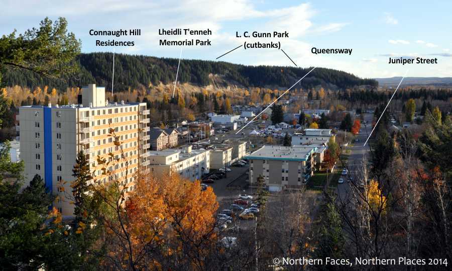
Looking to your far right from the park’s eastern viewpoint, the Connaught Hill Residences apartment tower and the Fraser River cutbanks dominate the landscape.
Looking Southeast (Viewpoint 3)
The main parking lot and its row of picnic tables face southeast (area 3 on the map). The view here is obscured by trees, but through them, catch glimpses of the Millar Addition and the cutbanks along the east shore of the Fraser River.

Beyond the main parking lot in Connaught Hill Park lies an open, grassy slope dotted with benches — the perfect place to watch the sun set over much of Prince George.
Looking Southwest (Viewpoint 4)
The park benches and open viewing area along the last section of the loop road face southwest (area 4 on the map). From here, almost half of Prince George stretches before you.
From the park bench at the far left of this viewing area:
- Look south (to your left) to see the residential areas of the Veteran’s Land Act (VLA) and South Fort George. Beyond the homes, at the point where the ridge of the cutbanks ends, look for vehicles moving over the Simon Fraser Bridge. This bridge crosses the Fraser River and carries Highway 97 traffic south to Quesnel and Vancouver. To the right of the bridge, a few colourful buildings form the northern tip of the B.C.R. Industrial Site.
- Immediately below you, to the southwest, lie the open grassy fields of Ron Brent Elementary School, a blue and grey building distinguished by its two flagpoles and two semi-circular entrance canopies. Above the fields sits a long, cream-coloured complex with gabled roofs and lots of windows; this is Gateway Lodge, an assisted living facility located at the corner of Victoria Street and 20th Avenue.
- The tall building midway between Gateway Lodge and the point of the cutbanks is Victoria Towers, a 12-storey affordable housing complex located at 20th Avenue and Norwood Street in the VLA.
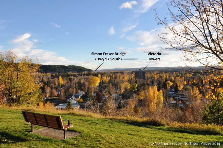
Looking south from the bench at the far left end of Connaught Hill Park’s main viewing area.

Gateway Lodge (left) and Ron Brent Elementary school dominate the foreground of this southwest-facing view from Connaught Hill Park. The hill at the centre of the photo sits at the intersection of Highways 16 and 97 and runs alongside Highway 16 as the road curls down into the Gateway neighbourhood. The hill is topped with two communications towers and is not open to the public.
From the park bench, walk to your right towards the picnic table in the middle of the viewing area. From the picnic table:
- Look west (to your right) to see Parkwood Place shopping centre and, behind it, the rectangular grey block of the University Hospital of Northern British Columbia. To the left of these buildings, the wide double lanes of 15th Avenue cut the city roughly in half on an east-west axis. In the distance stands Cedar Tower, Prince George’s first high-rise apartment, located on 15th Avenue near Highway 97 (Central Street).

The view west (to your right) from the picnic table on the main grassy viewing slope in Connaught Hill Park. For a clearer view in this direction, stop at the pull-out on your way out of the park, just before you begin your descent on the paved road.
- Still at the picnic table, look straight ahead (southwest) and scan the distant hilltops to find the University of Northern British Columbia (UNBC) nestled high above the city. Can you see University Way climbing up through the trees from the west?
- Directly under UNBC, at the base of the hill, you’ll see a long, low strip of buildings. This is the Carter Light Industrial Area bounded by Massey Drive, Ospika Boulevard, 15th Avenue and Highway 97 (Central Street).
- At the far left of this strip, the distinctive green dome of St. George’s Ukrainian Catholic Church rises above the trees at the corner of Massey Drive and Vanier Drive. At the far right of the strip, the College of New Caledonia sits obscured by trees.
- Near the centre of the strip, look for a white structure with a curved, dome-shaped roof. This building — and the radio tower right of it — sit on the BC Hydro property at 22nd Avenue and Highway 97.
- Below the BC Hydro site, you’ll find the spectator stands at Masich Place Stadium, home of the Prince George Track and Field Club.
- Take your gaze back to St. George’s Ukrainian Church. Just left of the green dome, through a small gap in the trees, you may see traffic moving back and forth along Highway 97 where the road passes over Massey Drive.

Looking straight out from the middle of Connaught Hill’s main viewing area (near the picnic table), you’ll see several city landmarks.


Pingback: New local history article: deciphering the view from Connaught Hill Park | Caroline Ross Creative
Pingback: Connaught Hill Park – Did you know? | Northern Faces, Northern Places